


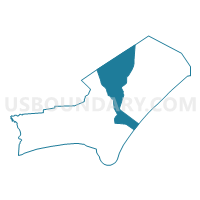
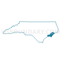
Voting District DAVI, Carteret County, North Carolina
About
Outline

Summary
| Unique Area Identifier | 639569 |
| Name | Voting District DAVI |
| County | Carteret County |
| State | North Carolina |
| Area (square miles) | 188.38 |
| Land Area (square miles) | 75.75 |
| Water Area (square miles) | 112.63 |
| % of Land Area | 40.21 |
| % of Water Area | 59.79 |
| Latitude of the Internal Point | 34.99590500 |
| Longtitude of the Internal Point | -76.46681020 |
Maps

Graphs
Select a template below for downloading or customizing gragh for Voting District DAVI, Carteret County, North Carolina


Neighbors
Neighoring Voting District (by Name) Neighboring Voting District on the Map
- Voting District 2OT, Pamlico County, NC
- Voting District 4HB, Pamlico County, NC
- Voting District CDIS, Carteret County, NC
- Voting District MERR, Carteret County, NC
- Voting District SLVL, Carteret County, NC
- Voting District SMYR, Carteret County, NC
- Voting District STAC, Carteret County, NC
- Voting District WILL, Carteret County, NC
Top 10 Neighboring County Subdivision (by Population) Neighboring County Subdivision on the Map
- Township 2, Pamlico County, NC (2,909)
- Township 4, Pamlico County, NC (2,268)
- Smyrna township, Carteret County, NC (787)
- Merrimon township, Carteret County, NC (605)
- Sea Level township, Carteret County, NC (522)
- Davis township, Carteret County, NC (426)
- Cedar Island township, Carteret County, NC (327)
- Stacy township, Carteret County, NC (214)
Top 10 Neighboring Place (by Population) Neighboring Place on the Map
Top 10 Neighboring Unified School District (by Population) Neighboring Unified School District on the Map
Top 10 Neighboring State Legislative District Lower Chamber (by Population) Neighboring State Legislative District Lower Chamber on the Map
Top 10 Neighboring State Legislative District Upper Chamber (by Population) Neighboring State Legislative District Upper Chamber on the Map
Top 10 Neighboring 111th Congressional District (by Population) Neighboring 111th Congressional District on the Map
Top 10 Neighboring Census Tract (by Population) Neighboring Census Tract on the Map
- Census Tract 9701.03, Carteret County, NC (3,046)
- Census Tract 9701.02, Carteret County, NC (2,608)
- Census Tract 9502.02, Pamlico County, NC (2,239)
- Census Tract 9901, Pamlico County, NC (0)
- Census Tract 9801, Carteret County, NC (0)
- Census Tract 9901, Carteret County, NC (0)
- Census Tract 9902, Carteret County, NC (0)
Top 10 Neighboring 5-Digit ZIP Code Tabulation Area (by Population) Neighboring 5-Digit ZIP Code Tabulation Area on the Map
- 28516, NC (11,431)
- 28571, NC (2,585)
- 28556, NC (963)
- 28579, NC (622)
- 28524, NC (426)
- 28520, NC (327)
- 28581, NC (214)
- 28589, NC (180)